A Woeful Tale
The story of the photographic mapping of the heavens is a woeful tale of failed attempts, over ambitious aims and misuse of valuable resources; and above all the wasted decades of effort on a project that was years ahead of its time and as a consequence lacked the necessary technology to succeed. In the end all became well with the introduction of the modern digital computer, searchable databases, mass storage devices and astrometric satellites.
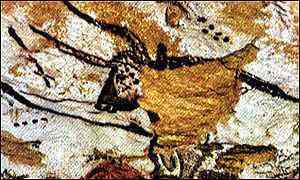
‘Ice Age Star Map’, from a Cave at Lascaux, France, circa 14,500 BC
Mapping the Stars
It was not long after the first photographs of stars were obtained in the 1850s that astronomers such as George Phillips Bond and Lewis Morris Rutherfurd began thinking about mapping the stars with the aid of a camera. The operative word here is ‘thinking’. At that time the currently preferred wet collodion process could only obtain impressions of stars down to magnitude nine at best.
It was only following the introduction of mass produced Gelatino-Bromide ‘Ddy’ photographic plates in the late 1870s and early 1880s, which were capable of obtaining well defined images of stars as faint as the 15th magnitude that the technology had matured sufficiently enough for an adventurous pioneer to be able to make such an attempt.
The 'First Attempt'
During the period May to December 1885, the English amateur Isaac Roberts (1829-1904) had taken a number of images with his 20-inch Reflector of regions of the sky 2 x 1.5 degrees in area. His aim was to complete a photograph sky chart of that part of the heavens visible from his observing location, near Liverpool, England. He shortly afterwards abandoned what soon became clear a task that was best left to professional observatories with their far greater resources.
Cape Photographic Durchmusterung
The history of Photographic Sky Charts began well with the successful completion of the Cape Photographic Durchmusterung, a joint project between the Cape of Good Hope Observatory, South Africa and the University of Groningen. It was published between 1896 and 1900 and listed the positions and magnitudes for 454,875 stars down to about magnitude 10.2 in the Southern Hemisphere for Declinations from -18S to -90S.
The 'Carte du Ciel'
In the April of 1887 a congress was held in Paris at the instigation of Ernest Barthelemy Amédée Mouchez (1821-1892), Director of the Paris Observatory with a view to encourage the cooperation of overseas observatories in the production of a photographic chart of the entire sky - a ‘Carte du Ciel’ (CDC). It was attended by 58 astronomers representing observatories and institutions from 19 countries.
At the end of the Congress the delegates agreed in principle to photograph, catalogue and map the positions of millions of stars as faint as the 11th magnitude and ultimately to extend this to those of the 14th magnitude. It was a project doomed to fail from the very outset. Sadly, despite the best will in the world and lots of promises the work was dogged by delays and problems. The zones allocated to several observatories had to be given to others, as they had failed to even begin the work or were not able carry on because of political unrest or war.
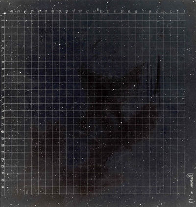
Astrographic Catalogue Plate: Image courtesy of the Royal Greenwich Observatory Archives
Problems
In 1900 the zones originally assigned to La Plata Observatory, Argentina were given to Cordoba, Argentina; whilst the zones originally assigned to the Rio de Janeiro Observatory, Brazil were given to Perth, Australia. In 1909, Hyderabad, India was assigned part of the zones originally to be done by Santiago Observatory, Chile; and in 1920 it was assigned the remainder of those originally given to Santiago.
Following the end of the First World War the Potsdam observatory announced it could not continue with the project. Its zones were reassigned to Uccle, Belgium, Hyderabad and Oxford. An allied bomb in the Second World War destroyed virtually all of the 1226 plates taken at Potsdam. Only 406 plates were ever measured.
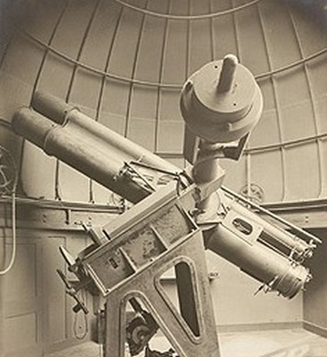
Carte du Ciel Astrograph, 1891: Photographycourtesy of the Cape of Good Hope Observatory
Failure
The project was a complete and utter shambles. In 1970 at the International Astronomical Union’s 14th General Assembly held in Brighton, England, it was finally acknowledged that after an interval of more than eighty years after its inception, the Carte du Ciel enterprise remained unachieved.
The Astrographic Catalogue part of the CDC project, containing stellar positions and magnitude down to the eleventh, were published between 1902 to 1964, and resulted in 254 printed volumes of printed data. The more ambitious Carte du Ciel Charts for stars down to magnitude 14, were never completed and only one Observatory, Greenwich ever published them.
POSS I & II
On the 11th November 1949 whilst the CDC was struggling along in its final death throes, the technology which it so badly needed began to appear. On a mountain in San Diego County, California, 5570 feet (1700 metres) high, a telescope undreamed of in Ernest Mouchez’s day opened its ‘eyes’ to the night sky. It was about to expose the first plate in the modern era of photographic sky surveys.
A year previously, the 48-inch Schmidt Telescope (now known as the Samuel Oschin Telescope) at the Mount Palomar Observatory was completed after nearly ten years in the making. It was not really a telescope at all, but a camera, for it was built from the outset with no provision for an eyepiece.
It was at the time the ultimate Astrograph. The Schmidt optical design enabled photographs to be taken of the sky which were completely ‘flat’ with no distortion of the star images at the edges; which meant the whole of the plate could be used and not just the inner part as was the case with the CDC plates.
The Samuel Oschin telescope was put almost immediately to good use in 1949, when it began work on the National Geographic Society sponsored – Palomar Observatory Sky Survey (NGS-POSS I). It was completed in 1958, less than ten years after it began – a feat which was meant to be achieved by the CDC.
Not satisfied with this great success, a Second Palomar Observatory Sky Survey (POSS-II) was performed in the 1980s and 1990s that made use of better, ‘faster’ dry plate technology and an upgraded telescope.
DSS I & II
In 1994 a digital photographic atlas of the entire sky in both hemispheres was completed, known as DSS I. For the northern sky, the Palomar Observatory Sky Surveys provided almost all of the source data. For the southern sky, images taken by the UK Schmidt Telescope at Anglo-Australian Observatory, were used. The publication of a digital version of these photographic collections has subsequently become known as the First Generation DSS.
In 1996, a more highly compressed version of the DSS was published by the Astronomical Society of the Pacific under the name ‘RealSky’. RealSky is searchable and includes software, which can be used to display any part of the sky up to one degree square, or find Deep Sky Objects (DSOs) which are included in the New General Catalogue (NGC).
Ten years later in 2006, the Second Generation DSS II was finished, and distributed on CDROM to partner institutions. Generally, the data are available through the websites of the partner institutions.
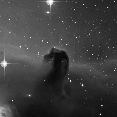
DSS Photographic Plate - 'Horsehead' Nebula: Photograph courtesy of Mount Palomar Observatory
HIPPARCOS and Redemption
The vast amount of effort invested in the CDC project looked for many years to have been a total and utter waste of time, only serving to keep busy those tasked with cleaning the dust that gathered on the tons of printed tomes it produced. But all is now forgiven, because this near century old star positional data has found itself to be of use, somewhat ironically in today’s world of satellites and digital computers - the very technology it lacked to succeed.
The European Space Agency’s (ESA) Hipparcos space astrometry satellite launched in 1989 was tasked with the job of creating a ‘Carte du Ciel’ for the twenty-first century. As part of the mission it was found possible to combine old data from the CDC project with Hipparcos measurements to enable highly accurate proper motions to be derived for some 2.5 million stars.
GAIA
In 2013 ESA plans to launch HIPPARCOS’s successor, GAIA – Global Astrometric Interferometer for Astrophysics. It derives its name from the Greek Goddess of Nature Gaia. Its capabilities go way beyond what HIPPARCOS achieved.
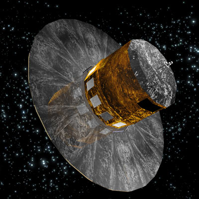
The GAIA Astrometric Satellite: Image courtesy of ESA
Quote
“It will often happen that when a picture is token of a portion of the heavens with which the worker is unfamiliar, identification of the principal stars on the plate is exceedingly difficult. Photographic and visual magnitudes differ very considerably; the scale, too, is smaller than a naked-eye view, and 20 minutes exposure on the crowded portions of the Milky Way on a good night will secure thousands of star images, the result of which is often absolutely bewildering.
A reversed image..is also confusing when comparing with an atlas, or portrait lens photographs. A good plan is to put a mark on the edge of the plate which, when in position, will be at the top side of the camera. Then with a good star atlas...the principal stars can soon be identified from the central star on which the telescope was guided. Some practice may be needed, but generally, after a little concentration, the whole group or constellation seems to jump into view, and the proper S. and N. points can be marked on the edge of the plate.”
Henry Hayden Waters (1880-1939), from Astronomical Photography for Amateurs, 1921.
To read more on this subject read the eBook chapter on Photographic Sky Surveys or buy the eBook 'Catchers of the Light'.
Buy the eBook or Printed Book at the 'Catchers of the Light' shop.